Leaving San Diego
It began with a plan, one that would eclipse the greatness of our last trip across the American west in 2009. This meant a more ambitious route that encompassed a larger area. I wanted to go as far north as Canada. So I threw in Vancouver and Victoria as two destinations. Then I chose the highways that would allow us to see the most places while also calculating the distances. What I came up with I ran by Dan, Thomas and Roberto via the Internet. We settled on one final route and that is what we stuck with.
 |
| The Road Map |
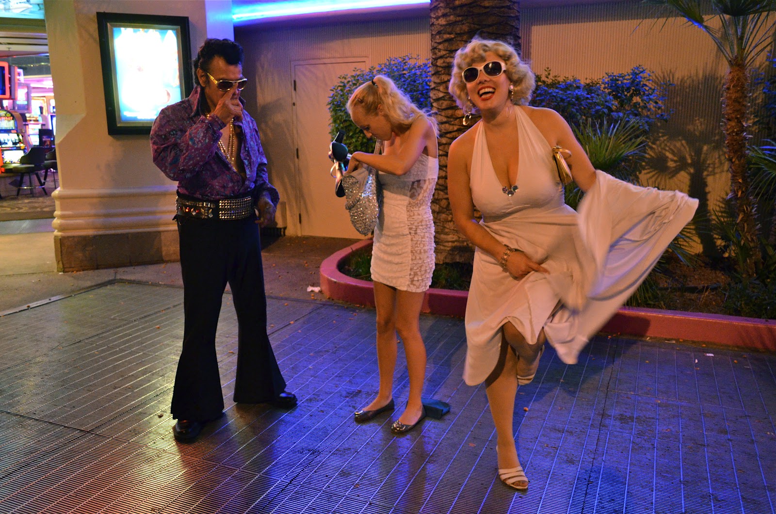
On August 3rd we set out from San Diego around 8pm. Roberto dropped out at the last minute because he had an issue at work. He said he would join up with us in the Seattle area. So we left without him and took the I-15 northeast to Las Vegas. We arrived late at about 2am but it was a Friday night and plenty of people were out and liquored up. Walking along the strip we overheard passer-byers making the most absurd of comments. They cared less what others might think. One woman complained about her large breasts attracting too much attention. Another guy who heard her said to his girlfriend that the large breasted girl should cover them up better if she didn’t want people staring. That made sense to me considering how low cut her black top was. Anyhow, it all reminded me of how pedestrians say things in a Grand Theft Auto game.
 |
| We arrive in Las Vegas |
 |
| Lights Galore |
Las Vegas has never been a city I have liked. Perhaps it is because I do not care for gambling. However, with all the casinos and their various themes it is a wonder to see. And these places are changing all the time. The Strip grows longer and those businesses that cant compete are torn down and replaced by larger, bigger buildings. From the street the facades are glamorous, and the insides are as equally impressive. The construction and maintenance costs are paid for with money lost by gamblers, and as long as they show up in droves the city will prosper.
 |
| A haven for MMA fighting |
 |
| A long exposure |
 |
| Dressed up for tips |
 |
| The Bellagio |
 |
| Impersonators |
 |
| Inside the casino |
We wanted
to eat something. Unfortunately, the first two places we had in mind (Shake ‘n
Bake and In ‘n Out) were closed. So we settled on Jack n’ the Box and their 24
hour drive thru. After that we went east to the Hoover dam. Security was tight
so we could not stop on the dam itself but from a parking lot a ways over we
could set up our tripods for photos. It was still early and the blue haze of
morning gave way to pink then orange. Another lookout gave us an ample view of
Lake Mead. At this point we should have rested up but I was determined to keep
driving towards the Grand Canyon. We linked up with the I-40 and cut across the
north Arizona landscape. First it was high desert but as we drew closer we saw
hilly woodlands and lastly even plains with short stubby trees that grew wide
apart.
 |
| The Hoover Dam |
 |
| Lake Powell |
 |
| More of the lake |
 |
| Desert sunrise |
Parks and Monuments
The Grand
Canyon was packed with tourists. They filled the large parking lots around the
main visitor center and walked in mass towards the south rim. We followed in
behind and came to the precipice. Thomas had never seen the canyon before so he
was quite impressed. But for me it had lost some of its majesty after my
previous five visits. Still I was pleased to have an opportunity to take
photos on a clear day. Our route took us east along the rim and we stopped
off at the occasional lookout. Then we exited the park and followed the
highways into Navajo country. This arid stretch of earth is a land like
no other. Smooth mounds rise from the hard desert floor and the sediments are
stacked in layers of white, grey and pink. Massive clouds float high on the
horizon and their shapes take on hard figures with thousands of bubbly curves.
 |
| The South Rim |
 |
| The visitor center |
 |
| A dead tree |
 |
| Inside the Indian tower |
When last we visited the Grand Canyon on our previous road trip we went to the North Rim. It is higher in altitude with more vegetation. However, for a first time visitor I would recommend the South Rim because it offers more lookouts, trails into the canyon, and is in my opinion more impressive.
 |
| The North Rim |
We pushed
on to Monument Valley which was right north of the Arizona/Utah border. The
area is worthy of National Park status but the Navajos run it independently for
financial gain. It was late in the day bit we still had some time before
sunset. A dirt road carved its way between the orange buttes until it took us
to an overlook of the park’s principal features. We caught them right as
the sun was dipping away for the night. Again Thomas was amazed by the
scale and expanse of the setting. However, Dan and I had visited only three
years before. This time though there was much better natural lighting for our
photos.
 |
| Arriving at Monument Valley |
 |
| Dream catchers |
 |
| Thomas is amazed |
 |
| A cowboy rides on |
Again, when it comes to photography, lighting is very important. Arriving at golden hour afforded us better shots. We were also fortunate that there were clouds in the sky, which add to the grandeur of the buttes and other geological wonders.
 |
| Monument Valley midday |
The drive
was not yet done. We went north for a few hours. On the way I stopped to get pictures of the stars. Shortly afterwards, the sun came up over the eastern horizon. I didn't have much time but I was able to capture some pictures, one of which came out quite nicely.
 |
| Desert moonrise |
We finally stopped at a Super 8 hotel in Blanding. That put us close enough to Canyonlands National
Park so that we could arrive early the following day. This park is up near Moab
in the same area as Arches, however it is much less visited than its neighbor.
That’s a pity because I find it to be the better of the two. In the Island in
the Sky part of Canyonlands is a mesa plateau that rests above flat land carved
up by river gorges.
 |
| The Utah sun |
 |
| Stopping for gas in Moab |
 |
| Canyonlands |
A park ranger recommended we take a hike from the mesa down to the White Rim Canyon. It was a long and arduous effort that took us to a place where there were not other tourists. Unlike mountain climbing the difficult part was the way back as we hiked up the switchbacks that were cut into the cliff wall of the mesa. Another problem was that we did not carry enough water and were all dehydrated at this point. Thomas complained that he was on the point of collapsing. Luckily, we made it back to the car where ice cold refreshments awaited us in the cooler. Overall the national park was very impressive, more so than nearby Arches.
 |
| On the way up |
 |
| A natural arch |
 |
| Posing between rocks |
 |
| Another sunset on the road |
Mormon Country
Canyonlands
ate up most the day and we did not have time to see Arches. As a result
we continued our drive and ended up at a Motel 6 somewhere between Provo and
Salt Lake City. Our plan was to go directly to Wyoming but we decided to see
the Mormon Temple the next day. At the visitor center Sister Stevens from
Kentucky and Sister Arias from Guatemala gave us a tour of the grounds. Under
their guidance we learned much about Brigham Young’s founding of Salt Lake City
and the Mormon faith’s growth in the area.
 |
| The teachings of Joseph Smith |
 |
| A wagon used to make the temple |
 |
| Mr. Brigham Young |
On an interesting note there went a story that seagulls saved the early settlers from famine. It began when crickets appeared and ate the crops the Mormons depended on. When doom seemed certain the seagulls swooped in from the sky and did away with the cricket. For days they took them in their mouths and dumped them into the Great Salt Lake before returning for more. For this reason these is a statue of seagulls outside the main church in the Temple area. I would have liked to go in and see the Temple too but only the most devout of Mormons may enter.
 |
| The Mormon Temple |
 |
| A church |
 |
| Inside with our guides |
After our
tour we went northwest of the city where a causeway crossed over the Great Salt
Lake to Antelope Island. The island is home to a herd of bison, antelopes and
many birds. The birds feast on flies that eat dead brine shrimp that was ashore.
It is quite disgusting because there are millions of flies and they move like a
black blanket, one which hovers slightly above the ground. We had to move
through it to arrive at the water. The lake is anywhere between 10 and 30
percent salt. This increases the density and in turn gives more buoyancy.
Without much of an effort anyone can float on the surface. The one problem is
keeping water from the eyes. It will sting uncomfortably and the walk back to
the showers to wash them out is a ways from the beach. Before we left we had
bison burgers at a café. They were pretty good, especially the bun.
 |
| The Great Salt Lake |
 |
| Going in |
 |
| Dan and Thomas float |
 |
| Wyoming mountains |
 |
| Plenty of cattle everywhere |
 |
| Overlook from our campsite |
 |
| The sun sets |
The sky darkened and the stars appeared. It was one those moonless nights where the Milky Way cut across the heavens in a diagonal swath. Not wanting to forget the most beautiful stars I had seen in years I put my camera to good use and captured some wonderful star fields. Then when we retired to the tent to unwind we kept hearing some noise form outside. But every time we looked there was nothing there. Dan finally spotted a pair of mice that were digging through a box of Ritz crackers we had left out. They actually looked more like kangaroo mice, and were quite cute.
 |
| The Milky Way |
Wyoming
We arrived at Jackson, WY and this was American territory I had never before seen. The small town swells with tourists during the summer because it is the gateway to Yellowstone to the north. We did not spend too much time there, but from what I saw it had an old western feel complete with saloons and art galleries.
Before reaching Yellowstone via Jackson, one must cross through Grand Tetons National Park. We decided to spend a day checking out the park with its big peaks and several lakes that sat in lush forest. The stop off included some hiking along Jenny Lake. The trail we took was inundated with tourists most of whom seemed European. I could always smell the French ones before I saw them because of their heavy perfume. In spite of the crowds I could still enjoy the terrific scenery. And at one point we saw a large healthy elk tearing up grass from the side of the trail. He seemed indifferent to the tourists that stopped and snapped photos. So we waited until he moved away from the trail before continuing on our way.
Yellowstone Park came next. It was the world's first national park established back in 1872. The place is recognized for its geysers and other geothermal features. Most people know about Old Faithful. It shoots a large jet of hot water 100-185ft into the air every hour and a half. We were on hand to see this performance alongside several hundred other spectators. According to the park's brochure some 2 million people visit every year. But Old Faithful aside there are many other features of a different nature. Some produce mud pools that bubble at the surface. Others are clear with an array of colors that are the result of minerals and bacteria. Bacteria are the only things that can survive in the scalding hot waters.
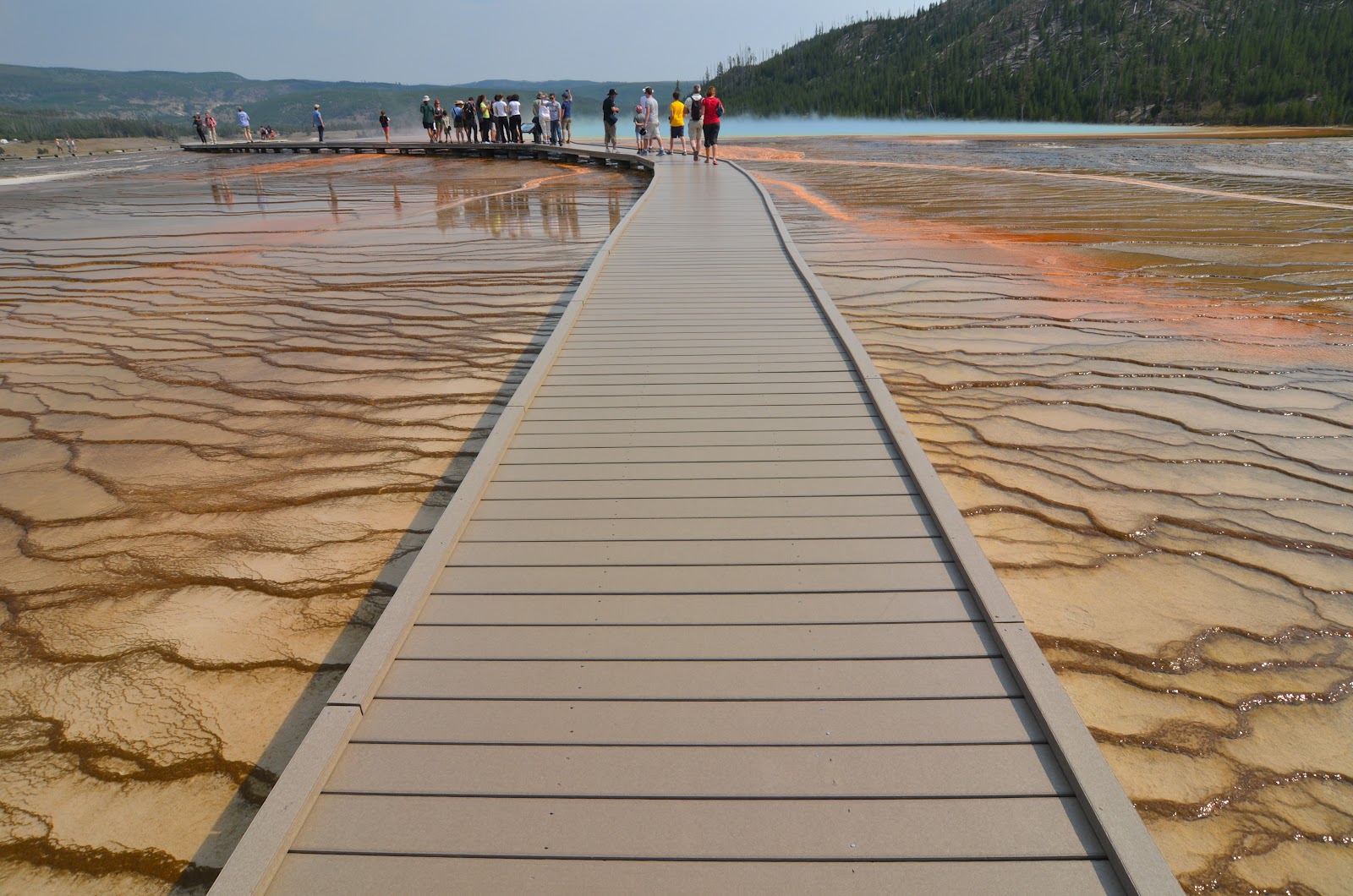
For us the most impressive geothermal wonder we saw was the Grand Prismatic Spring. It was so large we could walk within it on an elevated platform. Signs warned us to not fall off. Apparently many people have died from the scalding waters. I already knew better having been around several hot springs in Japan.
Because Yellowstone has had national park status for so long it has served as a large nature preserve in an otherwise over hunted area. Yellowstone is in fact the one place where American bison herds have lived uninterrupted since prehistoric times. We saw several of the animals from the park roads. Along with wolves and bears, they can pose a danger to humans so it is best to keep a safe distance while photographing them. I also had the opportunity to take pictures of deer. They seemed accustomed to the presence of park visitors thus allowing photographers to get close. The brochure said to maintain a distance of at least 25 feet but many people did not do so. In the end, I was one of them.
|
|
Falls of Yellowstone's Grand Canyon
|
My one regret to all this was that there were no bears. I have seen a wild one and was hoping Yellowstone would change that. They sometimes come into contact with humans. They have even killed a few people over the years. It is mostly because they are drawn to the smell of food. Regardless if they harm visitors or not, those that come close to human facilities are shot on sight because they are considered dangerously aggressive. While camping in the park we secured our food in the car to avoid this problem. In any event bear attacks are uncommon. As are incidents where people fall in the scalding thermal waters. The biggest threat to people at the park interestingly enough is car accidents.
After Yellowstone we drove northwest into Montana. This state is nicknamed the Big Sky Country and it certainly felt that way because everything is so spread out. Unfortunately we were rushed so we did not stop off anywhere aside from a restaurant in Butte. As we kept going night fell. The highway took on altitude and we wound through high mountains. That led us into Idaho where we spent the night at a hotel Coeur d'Alene. The town straddles a large lake which is a popular summer resort spot. The following morning we saw a bit of the lake on a hike. It really was a beautiful area but again we had to press on toward Washington.
Pacific Northwest
The I-90 crossed the state line and after driving by Spokane, we were surprised to see that the eastern part of Washington became high desert. This stretch of nothing extended for over a hundred miles. But as we approached Seattle, trees and greenery filled in the hills and mountains. It was a Friday afternoon and heavy traffic awaited us outside the city. Our friends whom we we wanted to visit lived in an apartment on the north end of town. I hadn't seen them for ten years and was happy to catch up on old times. I used to work with one of them at a Japanese supermarket in San Diego. Since then Eddie had become a freelance graphic designer.
|
|
Arriving at Eddie's Place
|
That night we went to the downtown area and hit up a restaurant called the Tap House. The locale had 160 beers on tap. I ordered a sampler made up of six 4oz glasses. I also had a salmon artichoke burger which was absolutely delicious. Afterwards we went to a bar. Walking from place to place I did not recognize much of anything. It had been fourteen years since my last visit to Seattle but I had spent two weeks there. One thing that still held true was the urban feel of downtown with its tall buildings and hilly streets. The city is not as large as San Diego or Los Angeles but the center feels bigger. During the day we returned for sightseeing. The Market Place area and world's first Starbuck's were standouts. But one unexpected surprise was a back alley that wad walls covered in gobs of bubble gum. It was both disgusting and mesmerizing at the same time.
Roberto had said he would meet us in Seattle, but he flaked out. That meant it was again the three of us on the road. We went north to Vancouver on the I-5. A peace park and concrete arch marked the port of entry at the border. On the opposite side the city was still a half hour drive away. The road signs were now all in kilometers and to drive home this change there were other signs posted which said "thinkmetric." In Vancouver lived Henry a Chinese Canadian. We knew him from Japan, and were happy to see him along with his Japanese wife and 5-year-old son.
Henry decided to show us the local Chinatown. It was one of the oldest on the west coast but I was not so impressed. The area had supposedly been in decline because they put in parking meters on the streets and that drove away many of the customers. From there we walked to Gastown. On the way we passed through East Hastings. This part of downtown was infested with junkies. Henry said they all ended up there after city planners tore down all the low income housing to beautify Vancouver for the Olympics. As we walked through we saw several people smoking crack cocaine in broad daylight. Two men were bloodied up, one of which was being attended to by paramedics while a woman cried at his side. A block down we crossed a street and everything appeared normal again. It surprised me how abrupt the change was.
Unfortunately, we only had a half day to spend in Vancouver. Then it was off to Vancouver Island by ferry. The two-hour crossing cut through the channel which was adorned with countless islands. Chris, our contact in Victoria, was a man I knew from my days in Gotemba. He had married his then girlfriend and settled with her in Canada. But it was their dream to one day return to Japan. In the meantime Chris taught music at a high school. Since he was on summer holiday he had time to show us around. He first had arranged for us to spend the day kayaking in the harbor. I was pleased to discover that the kayaks had a rudder system which made them easy to control. Two paddles on the inside allowed me to steer right and left. Otherwise I would have needed to lean one way or the other to maneuver, and that might cause the kayak to capsize.
|
|
Crossing Over to Vancouver Island
|
Later in the day we stopped at a pub to enjoy a few drinks. This afforded us the opportunity to eat poutine, a dish of which I had heard a great deal. Originally from Quebec, poutine is a plate of french fries covered in gravy, bacon bits and cheese curd. It is a favorite among Canadians and the food did not disappoint. But trying it the one time was enough for me. I did not need all that grease clogging my arteries.
 |
| Driftwood |
 |
Rock Formations
 |
| Stepping Over Rocks |
 |
| Forest by the Coast |
|
Oregon and Farming
While we were on the farm we relaxed and had BBQ. The farm workers came by to visit and I talked with most of everyone. One of the Mexicans told me he was from Oaxaca. He had come up by truck, and the very day after arriving, started to work. What he and the others did was very laborious but they seemed happy. Apparently my cousin paid them well. There were workers from elsewhere in the US who took the same liking to the Bohemian lifestyle afforded to one on a farm. My cousin even offered me a position on the farm should I want to try it out.
 |
| All Business |
 |
| Jimmy Drinks |
 |
| Jimmy's Boy |
 |
| Thomas Takes a Plunge |
 |
| Cookin' Time |
Before we left one of the workers, Jimmy, brought his shotgun and rifle for us to shoot. I first took the shotgun and blew apart a cardboard box. The kickback sent a jolt from my shoulder to my spine. Next was the rifle which had less of a jolt and more accuracy. I let fly a bullet that tore through a tomato some 150ft away. Dan and Thomas took shots of their own. It was the first we had ever used a gun. And I must admit it was very exhilarating. Before every pull of the trigger my heart raced, and after every shot my ears rang.
The guy to whom they belonged said he used them to hunt dear. He would stalk them until he came within about 30 yards, then aim straight for the heart. That was the most humane way to kill an animal. By the time he walked to the body the thing would be dead. A bad shot on the other hand might only injure a deer, allowing it to run away and die days later in great pain.
Speaking of injuries, my cousin David had a messed up leg. Not too long before our arrival he had fallen from a ladder and broken his ankle. The doctors put him in a cast but that did little to slow him down. He was hobbling all over the place, and for long distances he hopped on the back of his quad. Like a king on a horse he rode around surveying his land. I could tell his workers had the utmost respect for him. The Mexicans in particular called David "el patron" a name befitting of him.
 |
| Dave Gets around on an ATV |
 |
| Picking Lettuce |
We spent two days at the farm and were once again on the road. Rather than go directly into California we took a detour to Crater Lake National Park. The park in comprised of a volcanic caldera that erupted only a few thousand years ago. Rain water and snow melt later filled in the sunken cavity thus forming the deep lake. Because it has no tributaries that bring in sediments, the water in Crater Lake is very clear. We arrived midday and walked down from the rim. Several people were by the water swimming. I went in myself but it was quite cold. So we did not linger long. Once back in car we paralleled the rim for a while but turned off on a southbound road and left the park behind.
 |
| Crater Lake |
 |
| A Wider View |
 |
| Kids Jumping In |
 |
| Wizard Island |
 |
| Sundown |
The plan was to get as far into California as we could, maybe all the way to Redding. However, I was too tired to drive late into the night. We ended up instead in a Motel 6 in the small town of Yreka. But it was good we turned in early. The next morning we were well rested for the long drive south. We made it to Sacramento first. The state capital building was open to the public and we walked through snapping our shots. The city had little else to see so we jumped back on the I-5. Originally, we had thought about going to San Francisco at this point. Thomas really wanted to see the Golden Gate Bridge. Dan and I were not so sure though. We had been there on our last road trip and figured we should go to Sequoia National Park. The problem was we did not have time for both. In the end we had our way and instead of going west to the coast we went southeast through the Joaquin River valley.
 |
| Beneath the Capitol Dome |
 |
| An Office Room |
 |
| Dan and Thomas Re-enter the Capitol |
 |
| Garden Out Front |
 |
| Country Style Breakfast |
Our last night on the road was spent on a stretch of road between Fresno and the park. We lucked out by finding a quiet lot behind an abandoned gas station. There we set up our tents and had a few beers. Seeing how we camped we had an early start the next day.
 |
| Another Gas Run |
 |
| Gas Station by where we Camped |
 |
| Daybreak Comes |
In the morning the sky was ominous, and the morning air cold. We took out our windbreakers and wore them in the park. It was still early when we pulled into the parking lot for the Sequoia Forest trailhead. Few visitors had arrived before us. This made it seem that the forest was there for us, and us alone. Because up to then, most of the trails we walked in the other National Parks were inundated with tourists. With so many people in the way, the charm and majesty of a natural setting loses something.
 |
| Into the forest we go |
 |
| Fallen to Fire |
 |
| Biggest of the Biggest |
 |
| Dan snaps a shot |
So there we were among the giants. The biggest of all was General Sherman, a 2,700-year old tree that towers 275ft tall. On its left side a fallen branch, as thick as a car, rested halfway in the loop around the tree's base. We took our pictures and moved on. Everywhere around us massive trunks toured high into the forest canopy. Some of them we could walk right up to. These monstrosities we not like everyday trees. They harkened back to an ancient time when an oxygen rich atmosphere allowed for larger creatures to inhabit the Earth. It was as if we were taking a trip into a world long since vanished.
 |
| Dwarfed |
The visit to Sequoia National Park concluded our great road trip. From there it was a straight shot on the I-5 to San Diego. Aside from traffic in LA, we made it back without any hassles. And so ended our adventure.
 |
| Still got these in some places |
In Conclusion
The trip was a whirlwind ride that spanned a mere 15 days. We were able to see everything we had planned for with the exception of San Fransisco. But because we skipped out on that we could go to Sequoia National Park instead. In any event, the territory we covered has to be among the most beautiful in the world. Utah in particular has amazing landscapes of multicolored earth which stretches to the horizon with blue sky and bright clouds overhead. I still have yet to see Bryce Canyon and Captiol Reef so I think I will be returning to Utah in the future. But I can't say for sure when it will be. There are so many places to see and not enough time. As for those who have not yet travelled the Great American West, I highly recommend you do. You won't be disappointed.